

Northern Arizona Road Trip: Red Rocks, Ancient Ruins & Desert Magic
Explore Northern Arizona's best on this 10-day road trip. From Grand Canyon to Sedona's vortexes, discover hidden gems, cultural sites & intentional travel beyond the crowds.
The first time I stood at the edge of the Grand Canyon at sunrise, wrapped in a blanket and clutching terrible coffee from a gas station, I understood why people cry when they see it. It's not just the scale, though, yes, it's absolutely massive. It's the feeling that you're looking at something that transcends human timescales entirely. A landscape carved over six million years that makes your problems feel appropriately small.
But here's what I didn't expect: the Grand Canyon ended up being just the beginning of my Northern Arizona love affair.
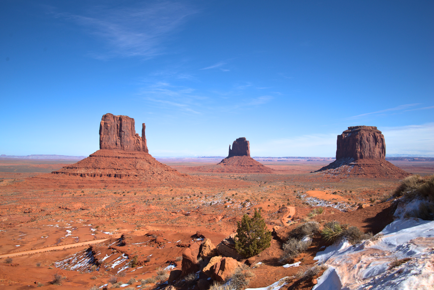
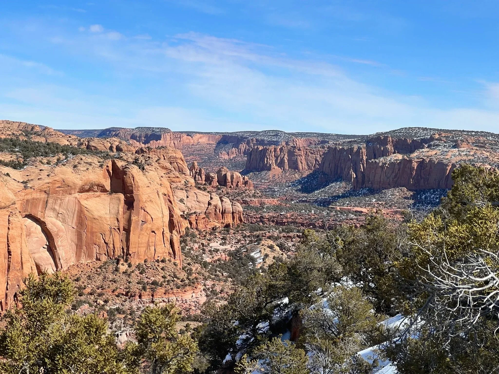
The real magic happened in the quieter moments, sitting in a Navajo-guided jeep listening to stories about Monument Valley's sacred formations, hiking through ancient cliff dwellings at Walnut Canyon with only the wind for company, watching light beams illuminate Antelope Canyon's curved sandstone walls, feeling the strange pull of Sedona's energy vortexes (yes, even skeptical me felt something).
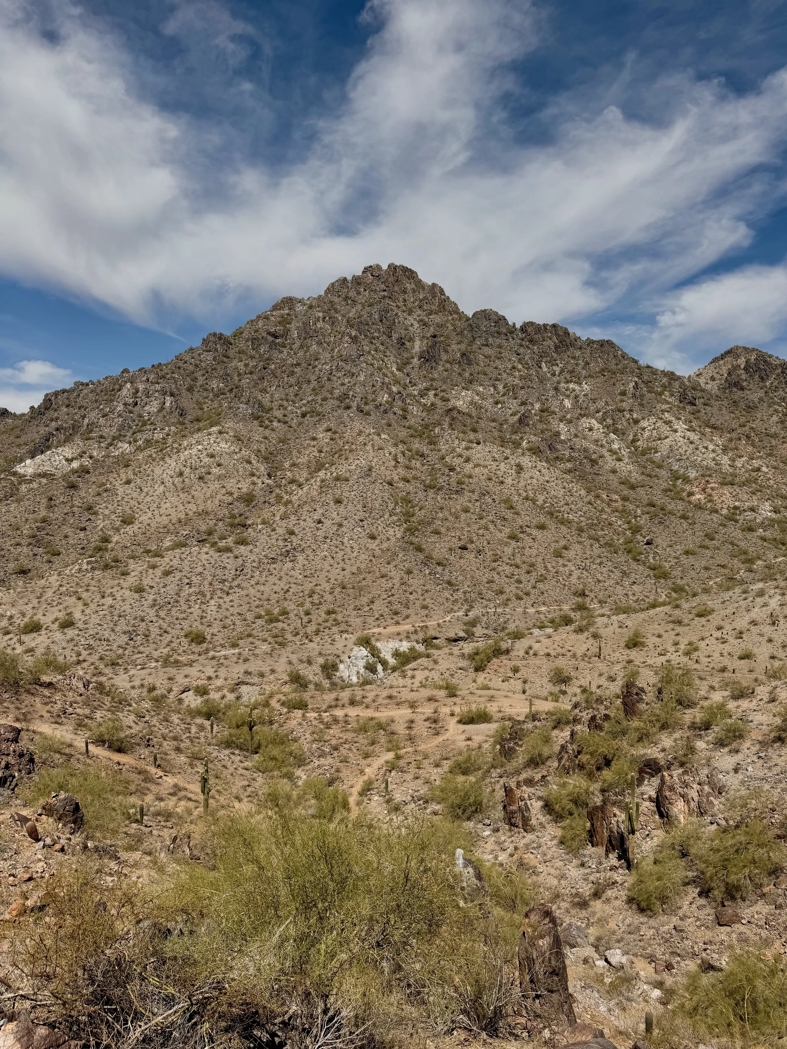
Northern Arizona is where the American Southwest reveals its full personality: dramatic, diverse, ancient, and deeply spiritual. This isn't just scenery, it's a landscape that has held meaning for Indigenous peoples for thousands of years, where every rock formation has a story, where the desert teaches you to slow down and pay attention.
This 10-day Northern Arizona road trip is for travelers who want:
Grand Canyon experiences beyond the crowded South Rim overlooks
Access to sacred Indigenous lands with cultural context and respect
Sedona's beauty without the woo-woo overwhelm (or with it, if that's your thing)
Hidden gems like Wupatki's ancient pueblos and the Painted Desert's otherworldly colors
Time to actually experience places, not just photograph and leave
If you're ready to trade Instagram clout for genuine wonder, let's plan the kind of trip that changes how you see the Southwest.
Planning Your Northern Arizona Road Trip
Best Time to Visit: Seasons & Strategy
Northern Arizona's high elevation (Flagstaff sits at 7,000 feet) means drastically different weather than Phoenix or Tucson. Choose your season wisely.
Spring (March-May): The Sweet Spot
This is prime time for a reason. Desert wildflowers bloom across lower elevations in April, temperatures are mild (50-70°F), and you'll avoid both summer heat and winter snow.
What to expect:
Grand Canyon can still have snow on the rim in March/early April (bring layers)
Sedona is perfect, with warm days, cool nights, and blooming cacti
Page/Lake Powell starts warming up (ideal for Antelope Canyon)
Expect crowds during spring break (late March), but they're manageable compared to summer
May is arguably the best month: warm weather, fewer families (school is still in session)
Pro Tip: Late April through early May is the hidden sweet spot, wildflowers are still blooming, the weather is warm but not hot, and crowds thin after spring break.
Fall (September-October): The Other Perfect Season
If spring doesn't work, fall is equally spectacular. Aspens and oaks turn golden in the high country, temps are comfortable (45-70°F), and the light is phenomenal for photography.
What to expect:
Early September can still be warm (and monsoon season lingers)
Mid-September through October is ideal—crisp mornings, perfect hiking weather
Fall colors peak in late September/early October around Flagstaff
Fewer crowds than spring overall
Grand Canyon North Rim closes mid-October (South Rim stays open year-round)
Summer (June-August): Hot but Manageable
Unlike Southern Arizona, Northern Arizona's elevation makes summer bearable, even pleasant, in Flagstaff and the high country.
Reality check:
Grand Canyon and Flagstaff are comfortable (60-85°F)
Sedona and Page get HOT (95-105°F)
This is peak season, expect crowds, especially at the Grand Canyon and Antelope Canyon
Monsoon season (July-August) brings afternoon thunderstorms, dramatic and beautiful, but dangerous for slot canyons
Book everything 3-6 months in advance
If you visit in summer: Start hikes at dawn, rest during the afternoon heat, and plan indoor activities (museums, air-conditioned restaurants) for midday.
Winter (November-February): The Quiet Season
Northern Arizona transforms in winter. Snow blankets the Grand Canyon rim, Flagstaff becomes a ski town, and you'll have places nearly to yourself.
What to expect:
Flagstaff gets 100+ inches of snow annually
Grand Canyon South Rim stays open but is cold (20-45°F)
Sedona is mild (40-60°F) and less crowded
Some roads close (Grand Canyon North Rim, high-elevation forest roads)
Shorter days mean less daylight for activities
Spectacular photography opportunities with snow on red rocks
Best for: Budget travelers (hotel rates drop significantly), photographers, and anyone who loves solitude
How Many Days Do You Need?
7 Days: Possible but rushed. Focus on the "Big Three": Grand Canyon (2 days), Sedona (2 days), Page/Antelope Canyon (2 days), plus travel time. Skip: Monument Valley, Prescott, lesser-known sites.
10 Days: The recommended sweet spot. Covers all major sites without feeling rushed, plus time for hidden gems like Wupatki, Walnut Canyon, and Jerome. This is what this guide focuses on.
14 Days: Luxury pace. Add Monument Valley (2 days), Canyon de Chelly, extended time in each location, and spontaneous detours. Perfect for travelers who want deep immersion.
My Recommendation: Don't do Northern Arizona in less than 10 days if it's your first time. This landscape demands slow appreciation. The magic happens when you're watching sunset light move across Canyon walls or talking with a Navajo guide about the spiritual significance of formations—experiences you can't rush.
This post contains affiliate links. I may earn a commission if you purchase through my links, at no extra cost to you.
Starting Points: Phoenix vs Las Vegas vs Flagstaff
Phoenix (Most Common)
Largest airport, most flight options
2.5 hours to Sedona, 3 hours to Flagstaff
Route: Phoenix → Sedona → Flagstaff → Grand Canyon → Page → Monument Valley → return
Pros: Easy flights, good rental car selection, and can explore Scottsdale/Phoenix for a day
Cons: Long initial drive to Northern Arizona, Phoenix summer heat if connecting flights
Las Vegas (Best for Canyon-Heavy Routes)
4.5 hours to Page, 4 hours to Grand Canyon (South Rim)
Route: Vegas → Page → Grand Canyon → Flagstaff → Sedona → Phoenix
Pros: Shorter distance to Page/Grand Canyon, interesting contrast (Vegas excess → desert minimalism)
Cons: Longer drive to Sedona, potentially more expensive flights
Flagstaff (Underrated Option)
Small regional airport with limited flights
Centrally located to everything
Route: Perfect loop from Flagstaff
Pros: Wake up IN Northern Arizona, skip long drives from Phoenix/Vegas, charming town
Cons: Fewer flight options, sometimes more expensive, smaller rental car selection
My Recommendation: Fly into Phoenix, out of Las Vegas (or vice versa) for a one-way road trip. This creates a logical route without backtracking and lets you experience more. Most rental companies allow one-way rentals for a reasonable fee ($50-100).
Compare flights on Booking.com and set price alerts. I've saved hundreds by booking on Tuesday afternoons when airlines release deals.
Budget Breakdown: Real Costs
Based on my trips and 2026 pricing:
Budget Version: $1,200-1,800 per person (10 days)
Camping/budget motels: $30-80/night
Cook most meals: $15-30/day
Gas: $200-300 (1,500-2,000 miles)
Park/site entrance fees: $100-150
Free or low-cost activities
Mid-Range Version: $2,200-3,200 per person
Mix of chain hotels and unique stays: $100-180/night
Eating out for lunch/dinner: $50-75/day
Gas: $250-350
Entrance fees + some guided tours: $300-500
Antelope Canyon tour, Grand Canyon helicopter, etc.
Comfort Version: $3,500-5,000+ per person
Boutique hotels and resorts: $200-400/night
All meals at quality restaurants: $80-120/day
Gas: $300-400
Multiple guided experiences: $600-1,000+
Helicopter tours, private Navajo guides, hot air balloon rides
Hidden Costs People Forget:
Antelope Canyon tour (required, can't go without a guide): $60-100/person
Grand Canyon National Park reservations for camping: $20-35/night
Navajo Nation entrance fees (separate from National Parks Pass): $8-25/person
Parking in popular towns (Sedona): $5-20/day
Gear you might not have (microspikes for winter, hiking poles): $50-200
Money-Saving Strategies:
Buy groceries in Flagstaff or Sedona (cheaper than tiny towns or Page)
Camp where possible (Grand Canyon campgrounds are spectacular and cheap)
Visit free sites: Sunset Crater, Wupatki, many viewpoints
Travel in shoulder season (early May, late September) for better hotel rates
Use Hostelworld to find affordable lodges in Flagstaff or Hipcamp for unique camping on private land with amenities.
Essential Logistics & Packing
Do You Need a 4WD or AWD?
Short answer: Not essential, but helpful for certain experiences.
What's accessible with a regular car/2WD:
All paved roads and major viewpoints
Grand Canyon South Rim (fully paved)
Sedona's main attractions (Cathedral Rock, Bell Rock, etc.)
Page/Horseshoe Bend/Antelope Canyon
Flagstaff and surrounding areas
Monument Valley scenic loop (rough but doable in dry conditions)
What requires 4WD or high clearance:
Some Sedona backcountry roads (Schnebly Hill Road after rain)
Remote Grand Canyon viewpoints (Toroweap)
Backcountry camping areas
Some Navajo Nation dirt roads
My Recommendation: Rent a mid-size SUV or crossover. You get:
Ground clearance for rougher roads
Space for camping gear/luggage
Better in varied weather (snow possible in spring/fall)
Can handle most situations without paying for full 4WD ($40-60/day extra)
Exception: If visiting in winter (December-March) and planning to explore beyond main roads, spring for AWD. Northern Arizona gets snow, and mountain roads can be treacherous.
Compare rental prices across all providers at Booking.com. Reserve early (3+ months) for best rates.
National Parks Pass: Worth It?
America the Beautiful Pass: $80/year
What it covers:
Grand Canyon National Park ($35 individual entry)
Sunset Crater Volcano National Monument
Wupatki National Monument
Walnut Canyon National Monument
Plus 2,000+ other federal sites nationwide
What it DOESN'T cover:
Antelope Canyon (Navajo Nation, requires paid tour)
Monument Valley (Navajo Nation, $8-25/person)
Sedona Red Rock Pass (separate, $5-15/day)
State parks
The Math: Grand Canyon alone is $35, and if you visit 3+ national monuments/parks on this trip, the pass pays for itself. Plus it's valid for 12 months, so if you're planning other national park trips, it's a no-brainer.
Where to Buy:
Online at Recreation.gov (ships to your home)
At any park entrance station (but lines can be long)
REI stores (convenient if you need gear too)
Pro Tip: The pass covers the vehicle (everyone in your car) OR the pass holder plus 3 adults, whichever is better for your group.
What to Pack: Desert + Mountains Edition
Northern Arizona's elevation means you're packing for BOTH desert heat and mountain cold, sometimes on the same day.
Clothing (Layering is Essential):
Moisture-wicking base layers (My recommendations: women's & men’s tops)
Long-sleeve sun shirt (SPF rated)
Light fleece or puffy jacket (My recommendations: women’s & men’s jackets)
Convertible hiking pants (My recommendations: women’s & men’s pants)
Wide-brim hat (non-negotiable)
Buff or bandana (dust protection)
Broken-in hiking boots + camp shoes (men’s & women’s hiking boots)
Rain jacket (spring/monsoon season) (women’s & men’s rain jackets)
Sun Protection (Non-Negotiable):
SPF 50+ sunscreen (reapply every 2 hours)
SPF lip balm
Sunglasses (polarized recommended)
Buff or bandana (dust storms happen)
Essential Gear:
Headlamp (for slot canyons and early starts)
Trekking poles (lifesavers on steep descents)
Hydration system: 3L bladder + backup bottles
Microspikes (if visiting Oct-April)
Dry bag for slot canyons (electronics protection)
Binoculars (for canyon views and wildlife)
Reusable water bottle (refill at visitor centers)
Small daypack (for hikes)
Car Essentials:
Cooler (ice is cheap at gas stations)
Emergency kit: jumper cables, tire repair, flashlight
Extra water (1 gallon per person per day minimum)
Snacks (gas stations are far apart)
Trash bags (Leave No Trace)
What NOT to Pack:
Heavy suitcases (you'll be moving around a lot, travel light)
White clothing (red desert dust is unforgiving)
Expensive jewelry
Cell Service & Offline Maps
Let's be real: you'll be off-grid for significant portions of this trip.
Cell Coverage Reality:
Good: Flagstaff, Sedona, Williams, Page (in town), Grand Canyon Village
Spotty: Highway 89A through Oak Creek Canyon, parts of Highway 89
None: Large stretches between towns, Grand Canyon trails, backcountry
Don't rely on your phone for:
Navigation (download offline maps)
Emergency communication (see satellite device below)
Trail conditions (check at visitor centers)
Download Before You Leave:
Google Maps offline areas (entire Northern Arizona region)
GPS premium maps (topographic layers)
AllTrails Pro (trail reviews and GPX files)
Podcast episodes (long drives between parks)
Music playlists (streaming won't work)

The 10-Day Itinerary: Northern Arizona's Magic
Day 1: Phoenix to Sedona + Red Rock Introduction
Drive Time: 2 hours from Phoenix to Sedona
Overnight: Sedona (3 nights total)
Most road trips start with logistics, rental car pickup, grocery shopping, and adjusting to the drive. We're going to make Day 1 count.
Morning: Phoenix Sky Harbor Pickup (Arrive by 10 am)
Pick up your rental car, grab supplies at a grocery store near the airport (last major grocery for better prices), and head north on I-17.
Midday: First Stop - Montezuma Castle National Monument (Optional, 1-2 hours)
About 90 minutes into your drive, consider a quick detour to Montezuma Castle, a remarkably well-preserved 5-story, 20-room cliff dwelling built into a limestone cliff by the Sinagua people around 1100 CE.
Why it matters: This is your introduction to the ancient cultures that thrived in Arizona for thousands of years. The Sinagua people were sophisticated engineers. This dwelling sits 100 feet above the valley floor, requiring complex construction techniques we still marvel at today.
What to do:
Walk the paved 1/3-mile loop for views (you can't enter the dwelling itself)
Visit the small museum
Takes 30-60 minutes
Entry: $10/person (or free with America the Beautiful Pass)
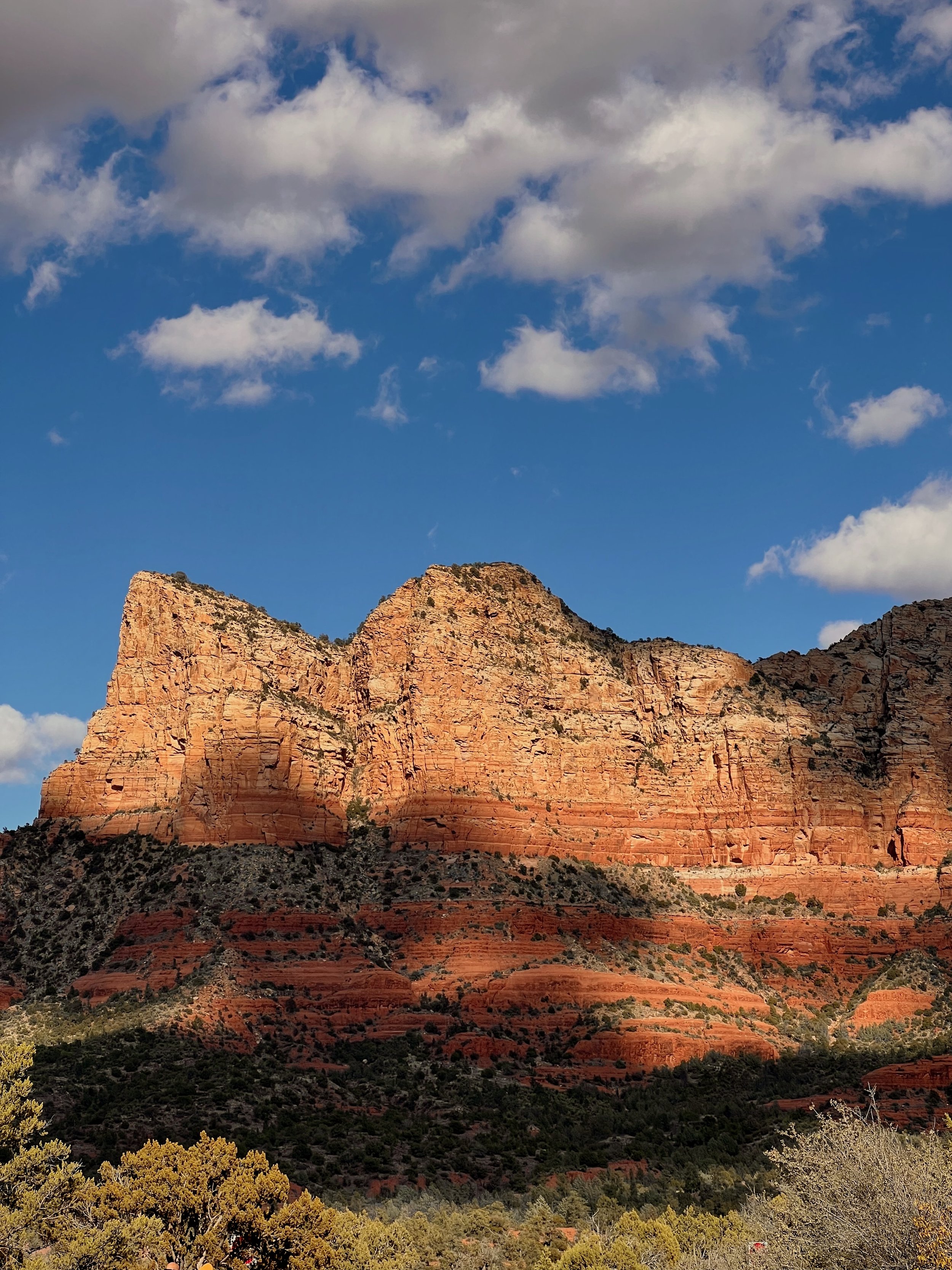
Late Afternoon: Arrive in Sedona (3-4 pm)
Drive Highway 179 into Sedona; this approach offers your first stunning views of the red rocks.
Check into your accommodation and take time to get oriented. Sedona is spread out with no real "downtown" in the traditional sense. Main areas:
Uptown Sedona - Tourist shops, restaurants, galleries
Village of Oak Creek - Southern area, more residential
West Sedona - Locals prefer this area, less touristy
Evening: Bell Rock Sunset (5-7 pm)
End your first day with an easy, spectacular hike to Bell Rock, one of Sedona's most iconic formations.
Bell Rock Pathway (3 miles round trip, easy-moderate):
Paved at first, then becomes a dirt trail
Crowds thin after the first viewpoint. Keep going
This is one of Sedona's famous "vortex" sites (areas of concentrated energy)
Sunset here is spectacular, the rock glows orange and red
Dinner in Sedona:
Elote Cafe (Mexican, reservations essential, $$$)
Pump House Station (Burgers, craft beer, great patio, $$)
ChocolaTree Organic Eatery (Vegetarian/vegan, healthy, $$)
Book Sedona hotels on Booking.com
Budget: Sedona Village Lodge ($100-150)
Mid-range: Arabella Hotel Sedona ($150-250)
Splurge: L'Auberge de Sedona ($400-600, creekside luxury)
Day 2-3: Sedona Deep Dive
Overnight: Sedona
Sedona deserves slow exploration. We're spending two full days here, balancing iconic hikes with hidden gems and cultural experiences.
Day 2: The Instagram Icons (But Smarter)
Sunrise: Cathedral Rock (6-8 am)
If you're doing ONE sunrise in Sedona, make it Cathedral Rock. This is Sedona's most photographed formation for good reason.
Cathedral Rock Trail (1.5 miles round trip, strenuous):
Starts easy, then requires scrambling over red rock slabs
Steep and exposed—not for those afraid of heights
The "saddle" between the spires is the goal
Sunrise from the saddle is transcendent
Crowd strategy: Be on the trail by 6 am (earlier in summer). By 8 a.m., it's a zoo.
Important: This trail is short but STEEP. Wear proper hiking shoes with grip. I've seen people attempt this in flip-flops—don't be that person.
Mid-Morning: Oak Creek Canyon Scenic Drive (9-11 am)
After Cathedral Rock, drive north on Highway 89A through Oak Creek Canyon, one of Arizona's most scenic drives. This winding road follows Oak Creek through a dramatic red rock canyon with towering walls.
Stop at:
Slide Rock State Park ($30/vehicle) - Natural waterslide formed by a creek flowing over slick rocks. Fun, touristy, crowded, worth it if you want to cool off.
Grasshopper Point - Swimming hole with cliff jumping (locals' favorite)
Midgley Bridge - Short hike to viewpoint over Wilson Canyon
Lunch: Stop in Oak Creek Canyon at Indian Gardens Cafe & Market (famous for fry bread tacos) or continue to Flagstaff for more options.
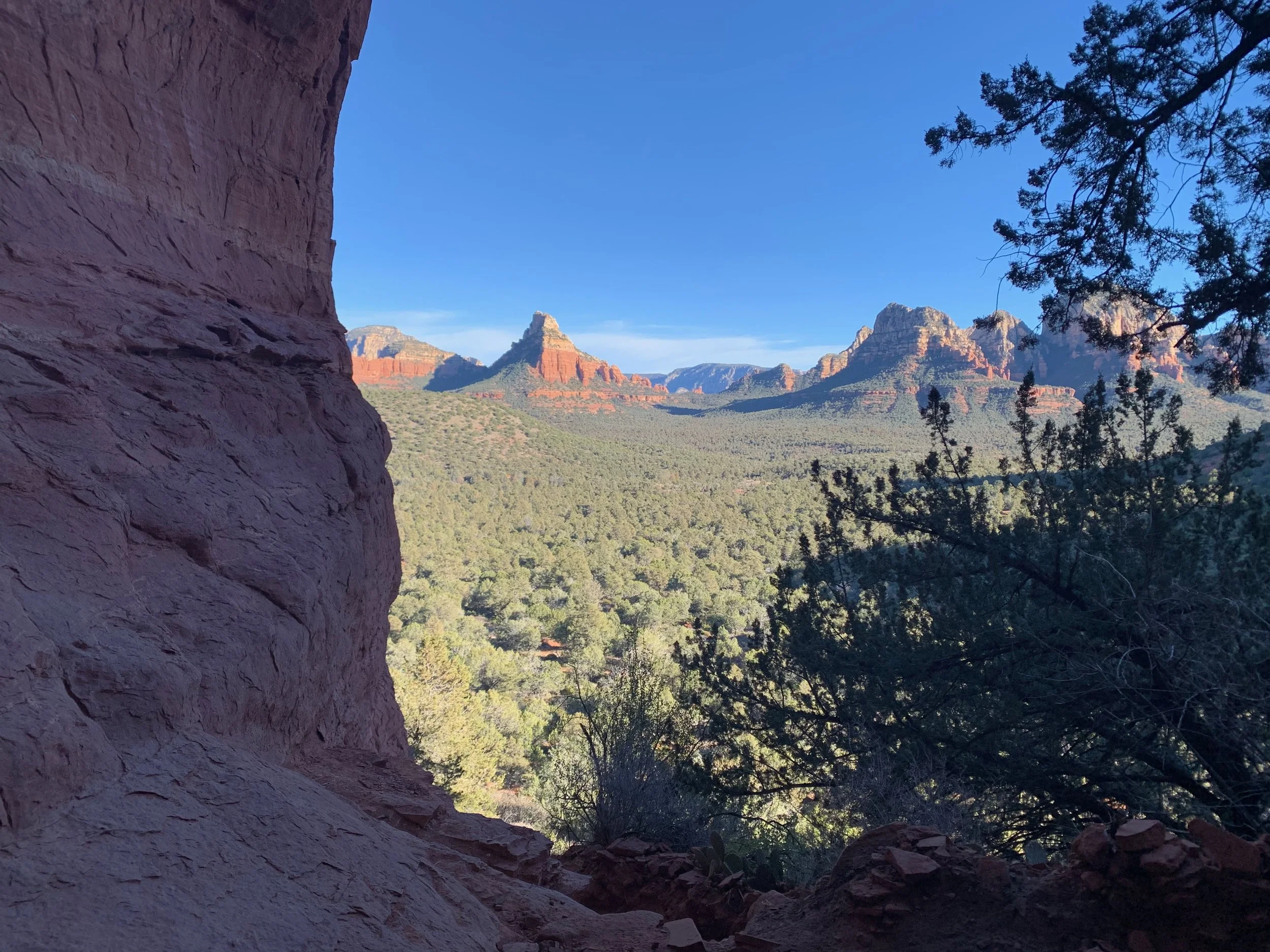
Afternoon: West Fork Trail (2-5 pm)
This is my favorite Sedona hike, and the one I recommend to everyone.
West Fork of Oak Creek Trail (7 miles round trip, easy):
Follows a creek through a narrow canyon
You'll cross the water 13+ times (wear water shoes)
Towering red rock walls on both sides
Shaded, peaceful, utterly magical
Fall colors here are spectacular
Why it's special: While everyone's fighting for views at Devil's Bridge, you're walking through a tranquil riparian canyon that feels like a secret garden. The further you go, the fewer people you'll see.
Entry: Red Rock Pass required ($5/day or $15/week)
Evening: Relax in Sedona. Browse Tlaquepaque Arts & Crafts Village (charming Mexican-style plaza with galleries), have dinner, and rest up for tomorrow.
Book a Sedona vortex tour with a local guide if you're curious about the spiritual side
Day 3: Hidden Sedona & Cultural Depth
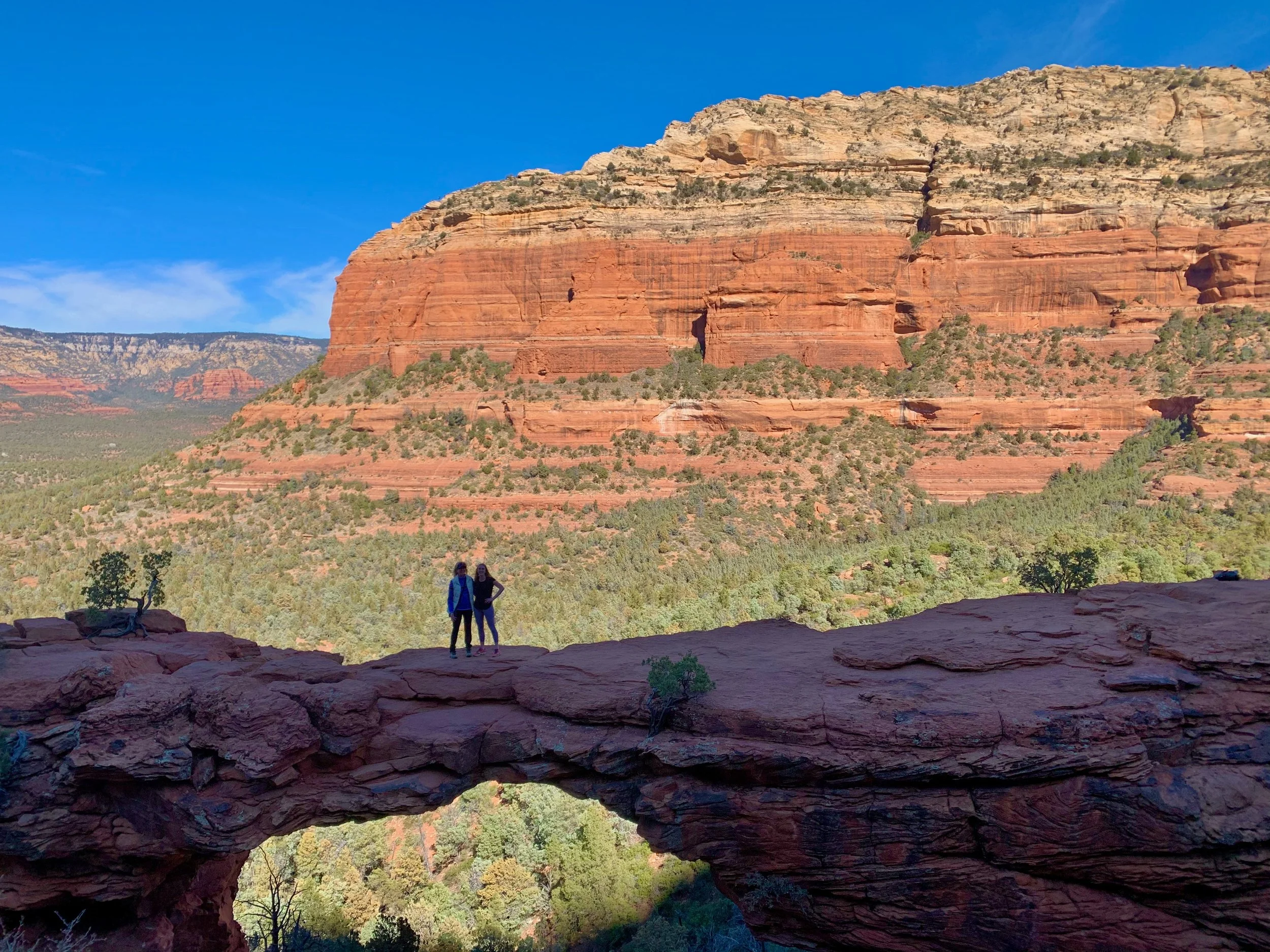
Morning: Devil's Bridge (7-10 am)
Yes, it's touristy. Yes, it's on every Instagram feed. But Devil's Bridge is iconic for a reason; it's the largest natural sandstone arch in Sedona.
Devil's Bridge Trail (4.2 miles round trip, moderate):
Can be shortened to 2 miles with a 4WD road approach (rough but doable in an SUV)
The arch itself is spectacular, a natural bridge spanning a canyon
Walking onto the arch is optional (and unnerving if you're afraid of heights)
The photo op is... exactly what you've seen on Instagram
Crowd strategy: START EARLY. I mean it. Be at the trailhead by 7 am, or wait until after 4 pm. Mid-morning is a nightmare, with hundreds of people waiting in line to walk onto the arch.
Midday: Jerome Ghost Town (11 am-3 pm)
After Devil's Bridge, drive 45 minutes to Jerome, a copper mining town perched precariously on Cleopatra Hill. Once called "the wickedest town in the West," it's now an eclectic artists' community.
What to do in Jerome:
Wander the steep streets (park and walk, driving is stressful)
Jerome State Historic Park - Douglas Mansion museum ($7 entry, great views)
Jerome Artists Cooperative Gallery - Local art
Nellie Bly Kaleidoscopes - Unique shop entirely dedicated to handmade kaleidoscopes (seriously)
Gold King Mine Ghost Town - Quirky collection of old mining equipment and cars
Lunch: Haunted Hamburger (brewpub, rooftop patio, great views) or The Asylum (upscale, in the old Jerome Grand Hotel)
Why Jerome matters: This town went from 15,000 people at its peak to nearly abandoned in the 1950s when copper mining collapsed. Now it's home to artists, eccentrics, and tourists seeking a glimpse of Arizona's Wild West past.
Late Afternoon: Tuzigoot National Monument (3:30-5 pm)
On your way back to Sedona, stop at Tuzigoot, another ancient Sinagua pueblo. This one sits on a hilltop overlooking the Verde Valley.
What makes it special: Unlike Montezuma Castle, you can walk through Tuzigoot's rooms and get a sense of how interconnected these pueblo communities were. The views from the top are sweeping.
Entry: $10/person or free with America the Beautiful Pass
Evening: Return to Sedona. If you're exhausted, grab takeout and relax. If you have energy, catch sunset at Airport Mesa (another vortex site with panoramic 360° views, and you can drive right to it).
Day 4: Sedona to Flagstaff + Ancient Wonders
Drive Time: 45 minutes Sedona to Flagstaff
Overnight: Flagstaff (2 nights)
Today's a transition day, but we're packing in three extraordinary ancient sites.
Morning: Final Sedona Sunrise at Airport Mesa (6-7:30 am)
Airport Mesa is the easiest sunrise spot; drive right to the viewpoint. 360° views of Sedona's red rocks bathed in golden light. This is your goodbye to Sedona.
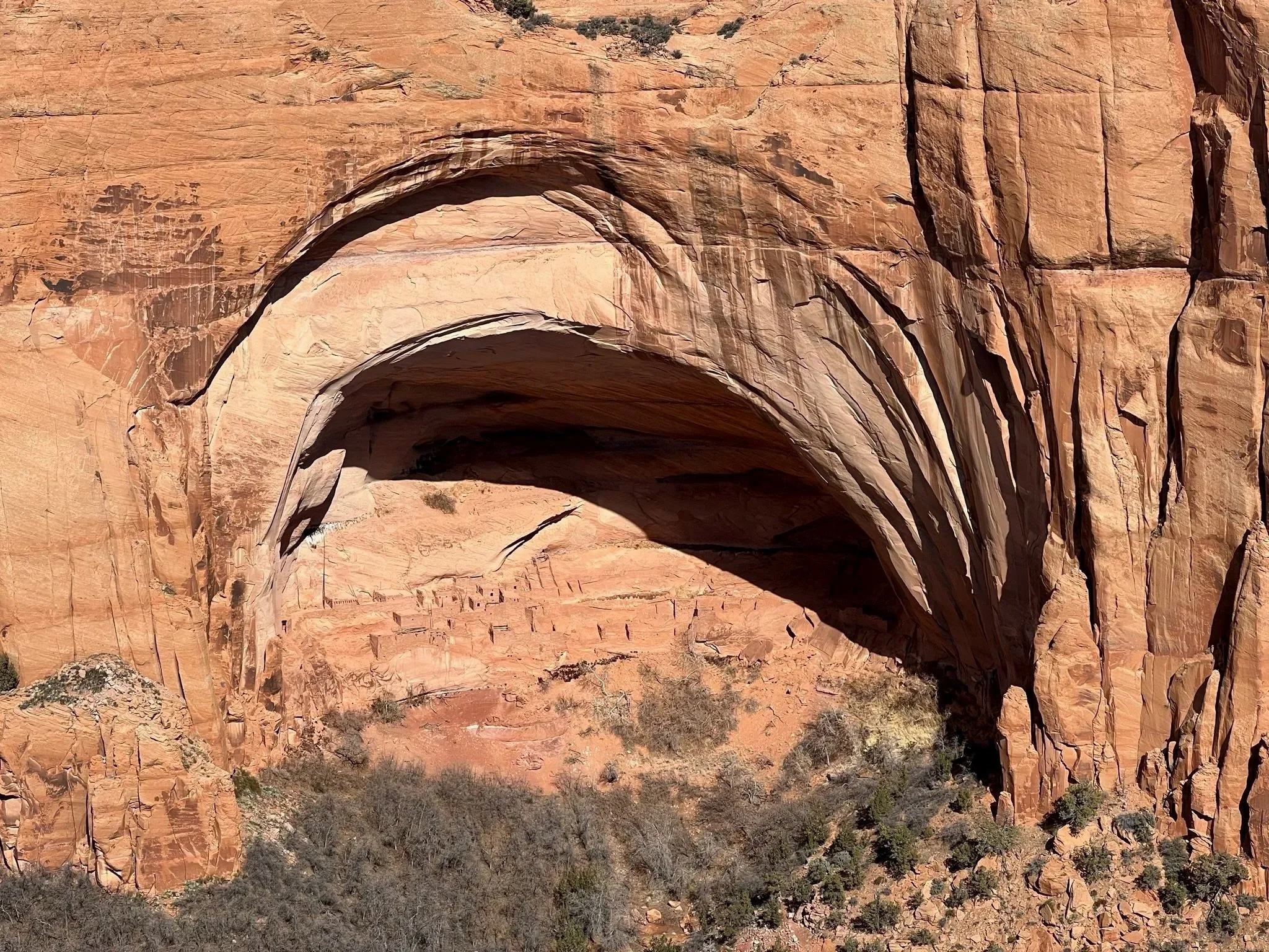
Mid-Morning: Drive to Flagstaff via Walnut Canyon (9 am-12 pm)
Walnut Canyon National Monument (1-2 hours):
This place blew me away. A limestone gorge carved 350 feet deep, with 25 ancient cliff dwellings built directly into the canyon walls by the Sinagua people around 1100-1250 CE.
Island Trail (1 mile loop, moderate but steep):
Descends 240 feet via stairs into the canyon
Walk past cliff dwellings built under rock overhangs
Peer into rooms where families lived 800 years ago
The descent is easy; the ascent back up will wind you (7,000 ft elevation)
Why it matters: These weren't primitive shelters; they're sophisticated multi-room homes positioned to capture sun in winter and shade in summer. The Sinagua people were master engineers who understood their environment intimately.
Entry: $15/person or free with America the Beautiful Pass
Cultural Note: While you can't enter the dwellings, you can look into them. Please don't touch the walls or take artifacts. These are sacred sites and archaeological treasures.
Afternoon: Lunch in Flagstaff + Check-In (12:30-2 pm)
Flagstaff is a proper mountain town, with pine forests, university energy (Northern Arizona University), Route 66 history, and actual seasons.
Lunch: Downtown Flagstaff has great options:
Toasted Owl Cafe (breakfast/brunch, excellent)
Pizzicletta (Neapolitan pizza, casual)
The Annex (craft cocktails, elevated pub food)
Check into your hotel and enjoy being in a real town after days in smaller communities.
Late Afternoon: Sunset Crater & Wupatki Double Feature (2-6 pm)
These two national monuments are connected by a scenic loop road northeast of Flagstaff. You can see both in one afternoon.
Sunset Crater Volcano National Monument:
In 1064 CE, a massive volcanic eruption created this nearly-perfect cinder cone and covered 800 square miles with lava and ash. The landscape still looks otherworldly.
Lava Flow Trail (1 mile, easy):
Walk across a frozen lava flow from the eruption
Black volcanic rock, jagged formations
Interpretive signs explain the geology
It's like walking on another planet
Wupatki National Monument:
Just a few miles from Sunset Crater, Wupatki preserves multiple ancient pueblos built after the volcanic eruption. The volcanic ash enriched the soil, creating farmable land that attracted people from across the region.
Wupatki Pueblo (largest structure):
Multi-story pueblo with 100+ rooms
Ball court (rare in this region, suggesting trade with Mesoamerican cultures)
Natural "blowhole" where cool air rushes out of the ground
Self-guided trail allows close-up views
What's remarkable: This wasn't one isolated group; Wupatki was a trading crossroads. Artifacts found here come from as far as the Pacific Coast, the Gulf of California, and Mesoamerica. This was a cosmopolitan hub 900 years ago.
Entry: $25/vehicle for both monuments (valid 7 days) or free with America the Beautiful Pass
Evening: Return to Flagstaff. Dinner and drinks downtown, Flagstaff has a surprisingly good craft beer scene.
Book Flagstaff hotels on Booking.com
Budget: Motel 6
Mid-range: Little America Hotel
Unique: High Country Motor Lodge
Day 5: Grand Canyon Immersion
Drive Time: 1.5 hours Flagstaff to Grand Canyon South Rim
Overnight: Grand Canyon Village (2 nights) OR Flagstaff
This is it, one of the Seven Natural Wonders of the World. We're spending two full days here because the Grand Canyon isn't something you "do" in a few hours.
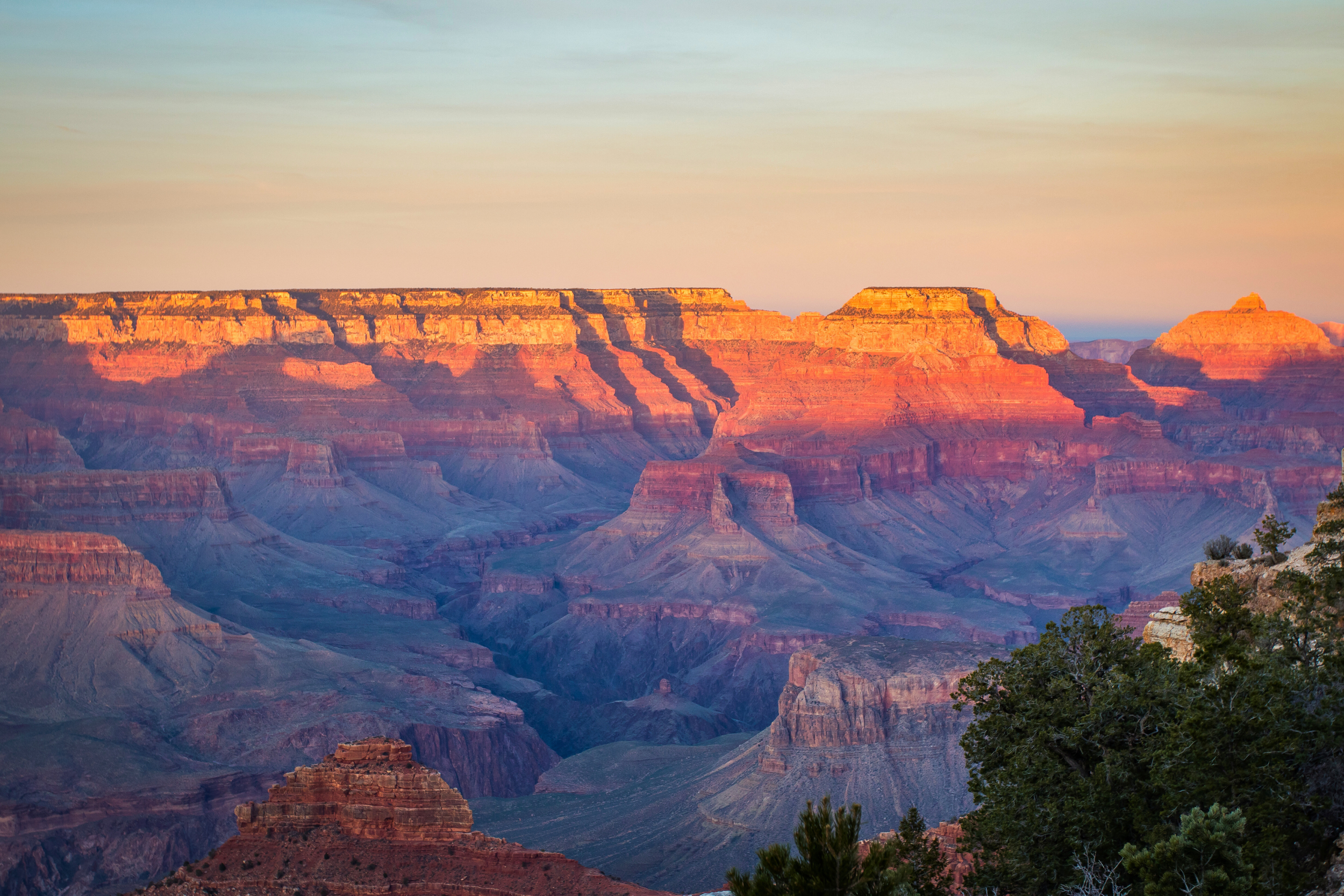
Pre-Dawn: Sunrise at Mather Point (5-7 am)
Drive from Flagstaff in the dark (yes, it's early, yes, it's worth it). Arrive at Mather Point 30 minutes before sunrise.
Why Mather Point: Easily accessible from the main entrance, it offers sweeping views of the canyon, and you can watch light creep across the canyon walls as the sun rises.
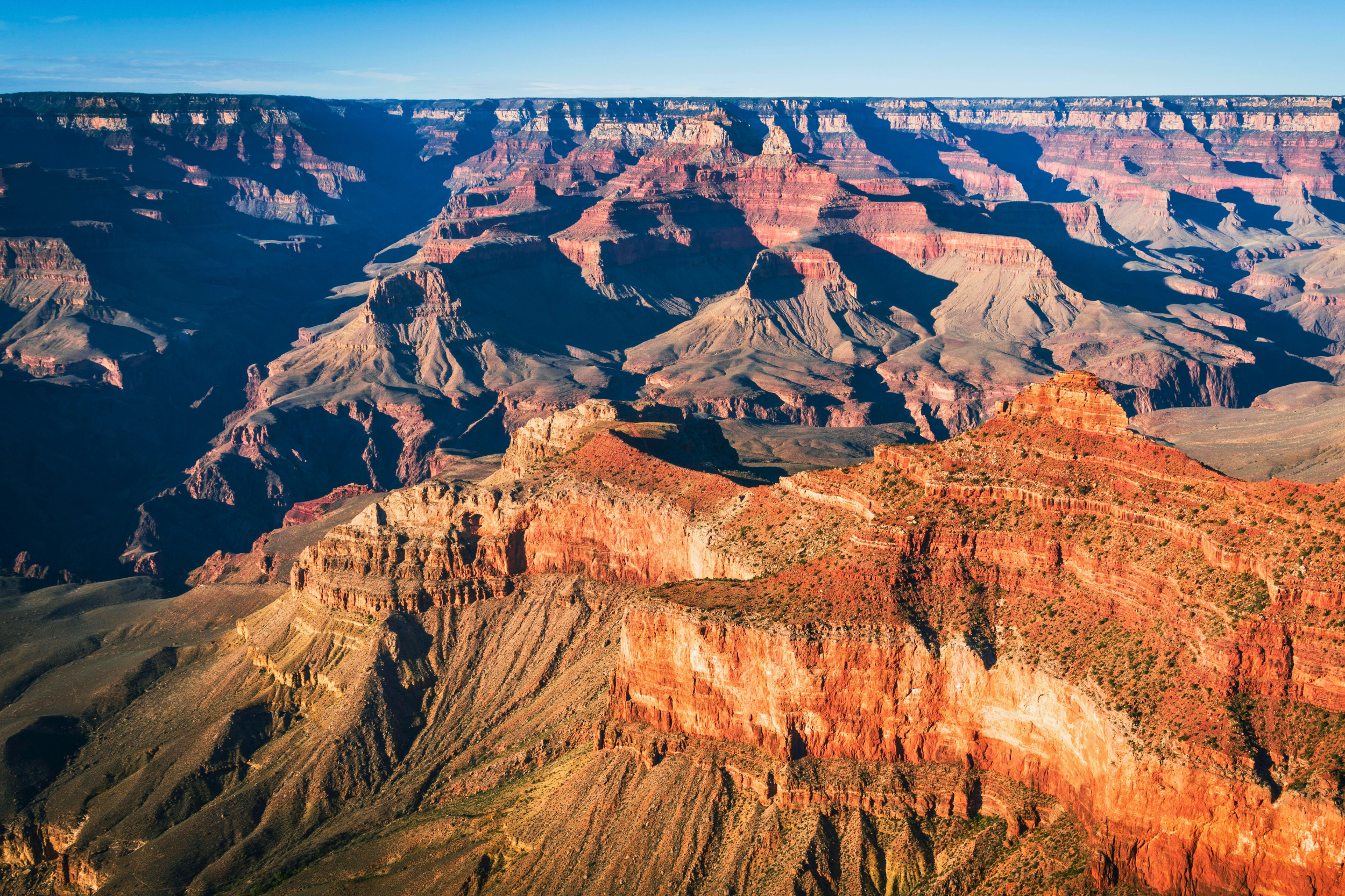
Morning: Rim Trail Walk (7:30-10 am)
After sunrise, walk the Rim Trail toward Yavapai Point. This paved trail follows the canyon rim and offers constantly changing perspectives.
Why walk instead of drive: Every 100 feet, the view changes. Different light, different shadows, different formations become visible. The Grand Canyon isn't one view; it's thousands.
Stop at Yavapai Geology Museum - Excellent interpretive displays explaining how the canyon formed over 6 million years. This will deepen your appreciation for what you're seeing.
Midday: Hike Below the Rim (10 am-3 pm)
Here's the critical decision: Do you hike into the canyon, or stick to the rim?
Option 1: Bright Angel Trail (3-6 miles round trip, strenuous)
This is THE classic Grand Canyon hike, steep, exposed, and absolutely worth it.
Suggested turnaround points:
1.5 Mile Resthouse (3 miles round trip, 1,131 ft elevation change) - Good for most fitness levels
3 Mile Resthouse (6 miles round trip, 2,112 ft elevation change) - Serious workout
CRITICAL WARNINGS:
Going down is easy. Coming back up is brutal.
Start early (by 7 am in summer) to avoid midday heat
Bring 3+ liters of water per person
Salty snacks (you'll lose electrolytes sweating)
This hike is no joke; people die here every year from heat exhaustion and dehydration
Rangers' rule: "Down is optional, up is mandatory." Don't hike farther than you can hike back up.
Why it's worth it: Getting below the rim completely transforms your understanding of the canyon. You're suddenly IN it, surrounded by walls, seeing layers of rock dating back 2 billion years. It's humbling.
Option 2: South Kaibab Trail (3 miles round trip to Cedar Ridge, strenuous)
Alternative to Bright Angel. Steeper, more exposed, but more dramatic views. No water available on the trail (unlike Bright Angel).
Option 3: Rim Trail Only (Easy, No Pressure)
If hiking into the canyon feels like too much, that's completely okay. Walk the Rim Trail, visit viewpoints via shuttle, and enjoy the spectacle from above. There's zero shame in this; the Grand Canyon is magnificent from every angle.
Afternoon: Rest, Explore Village (3-5 pm)
After hiking, you're exhausted. Return to your accommodation, shower, and rest. Explore Grand Canyon Village:
Historic El Tovar Hotel (grab a drink on the porch even if not staying here)
Hopi House (Native American arts and crafts)
Kolb Studio (historic photography studio, now a gallery)
Evening: Sunset at Hopi Point (5:30-7:30 pm)
Take the shuttle to Hopi Point for sunset; it juts further into the canyon than other viewpoints, offering 180° views.
Why sunset: The canyon transforms. Shadows deepen, colors intensify, and the scale somehow feels even more impossible.
OR drive back to Tusayan (just outside the park) for more options.
Book Grand Canyon lodging ASAP (books up 6-12 months ahead)
Inside Park: El Tovar (historic, $$$), Bright Angel Lodge ($$), Maswik Lodge (−- −$)
Tusayan: Grand Canyon Hotel & Suites ($150-250), Red Feather Lodge ($100-180)
Book a helicopter tour from Tusayan (splurge option, $200-400)
Day 6: Grand Canyon Deep Exploration
Overnight: Grand Canyon Village or Flagstaff
Your second Grand Canyon day allows deeper exploration—or a more relaxed pace if yesterday wiped you out.
Option 1: Desert View Drive (All Day Activity)
This 25-mile scenic drive takes you east along the South Rim to Desert View, a completely different perspective.
Key Stops (west to east):
Yaki Point - Shuttle access only, worth it
Grandview Point - Expansive views, less crowded
Moran Point - Where painter Thomas Moran sat to create his famous Grand Canyon paintings
Lipan Point - Best spot to see the Colorado River
Desert View Watchtower - Mary Colter's masterpiece, a 70-foot stone tower with Native American design
Why Desert View Watchtower matters: Architect Mary Colter designed this in 1932 as a "re-creation" of ancient Ancestral Puebloan towers, blending them with Hopi cultural elements. Climb to the top for 360° views.
Lunch: Desert View Trading Post (basic but decent)
Afternoon: Continue east to Cameron Trading Post (45 min from Desert View) for Native American crafts and a different landscape perspective, OR return west and hike a less-crowded trail.
Option 2: Less-Crowded Rim Hikes
If you want more hiking without the Bright Angel crowds:
Hermit Trail to Dripping Springs (6 miles round trip, strenuous):
Requires shuttle to Hermit's Rest
Steep descent to a natural spring alcove
Far fewer people than Bright Angel
Stunning views of the Hermit Creek drainage
Shoshone Point (2 miles round trip, easy):
Hidden viewpoint accessed by an unmarked dirt road
Locals' favorite, you might have it to yourself
Perfect for a quiet picnic
Option 3: Ranger Programs & Museums
Don't underestimate the value of ranger talks. These people are Grand Canyon experts, and their enthusiasm is infectious.
Check the schedule at visitor centers for:
Geology talks (how the canyon formed)
California condor presentations (endangered species success story)
Night sky programs (Grand Canyon is an International Dark Sky Park)
Evening: If this is your last Grand Canyon night, consider a star tour. The park offers ranger-led astronomy programs, or just bring a blanket to a viewpoint. The Milky Way over the Grand Canyon is unforgettable.
Day 7: Grand Canyon to Page + Horseshoe Bend
Drive Time: 2.5 hours, Grand Canyon to Page
Overnight: Page (2 nights)
Today's drive takes you through the Navajo Nation, a different landscape, a different culture, a different relationship with the land.
Morning: Leave Grand Canyon (8-9 am)
Take Highway 64 east to US-89, heading north toward Page. This drive crosses the Painted Desert, a landscape of striated badlands in shades of pink, red, purple, and gray.
Midday: Cameron Trading Post (Optional Stop, 10 am-11 am)
Historic trading post (established 1916) on the Navajo Nation. Great for:
Native American jewelry, rugs, and art (authentic, not tourist junk)
Clean restrooms (important on this drive)
Lunch at the on-site restaurant
Gallery featuring museum-quality pieces
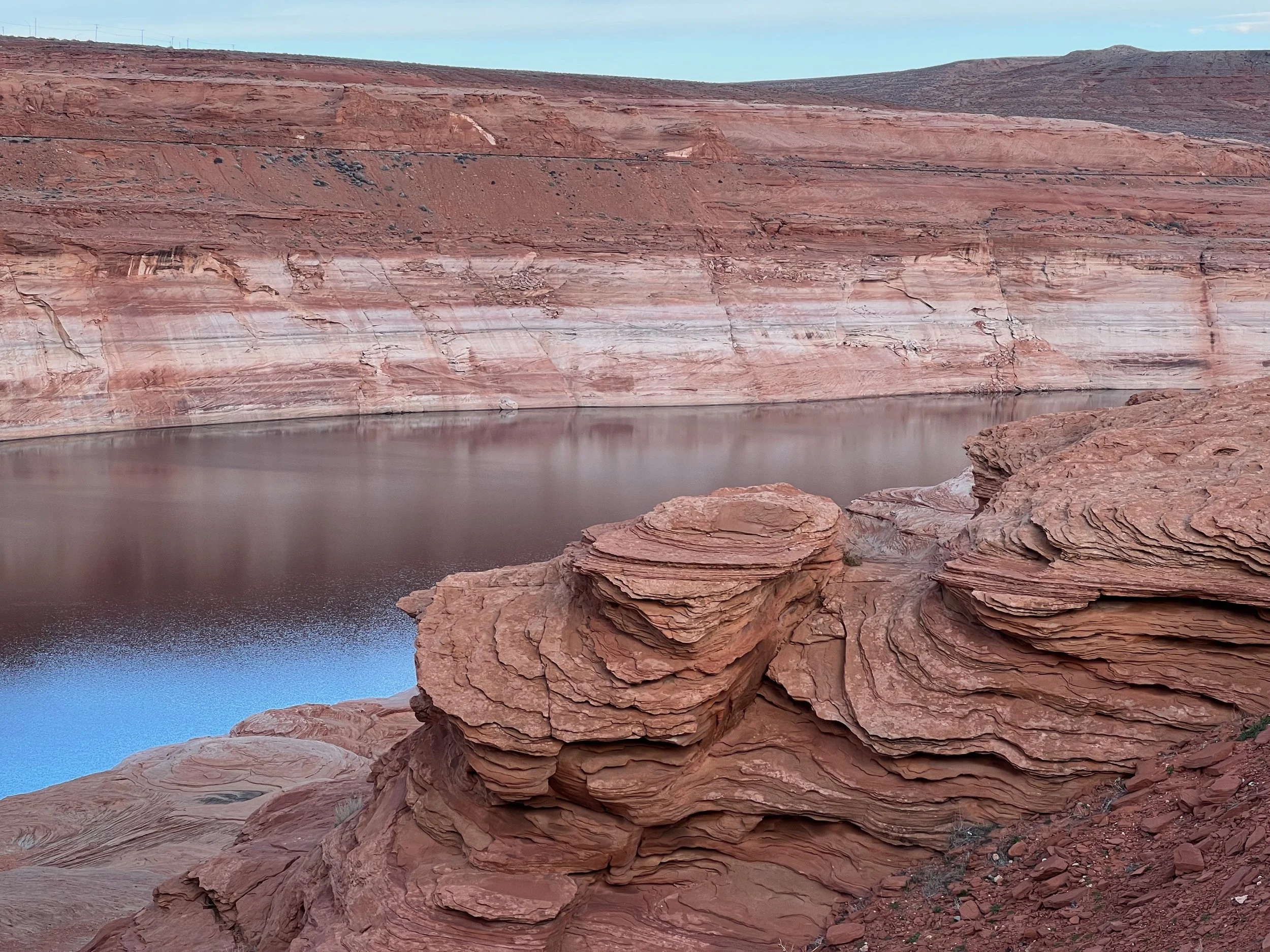
Arrive in Page (12-1 pm)
Page is a practical, not charming, town built to house workers during Glen Canyon Dam construction in the 1950s. It exists to service tourists visiting Lake Powell, Horseshoe Bend, and Antelope Canyon.
Check in, grab lunch, and prepare for the afternoon.
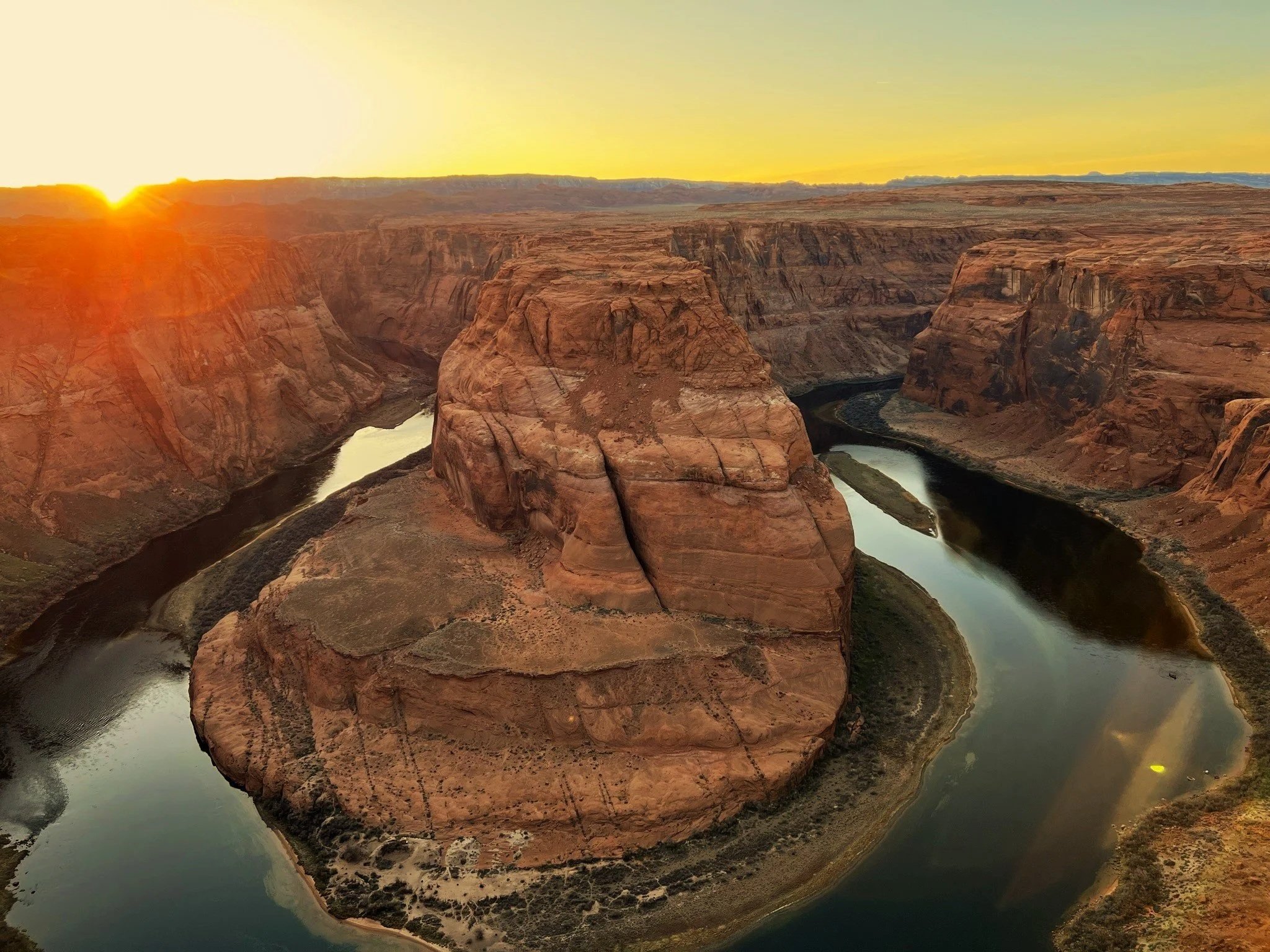
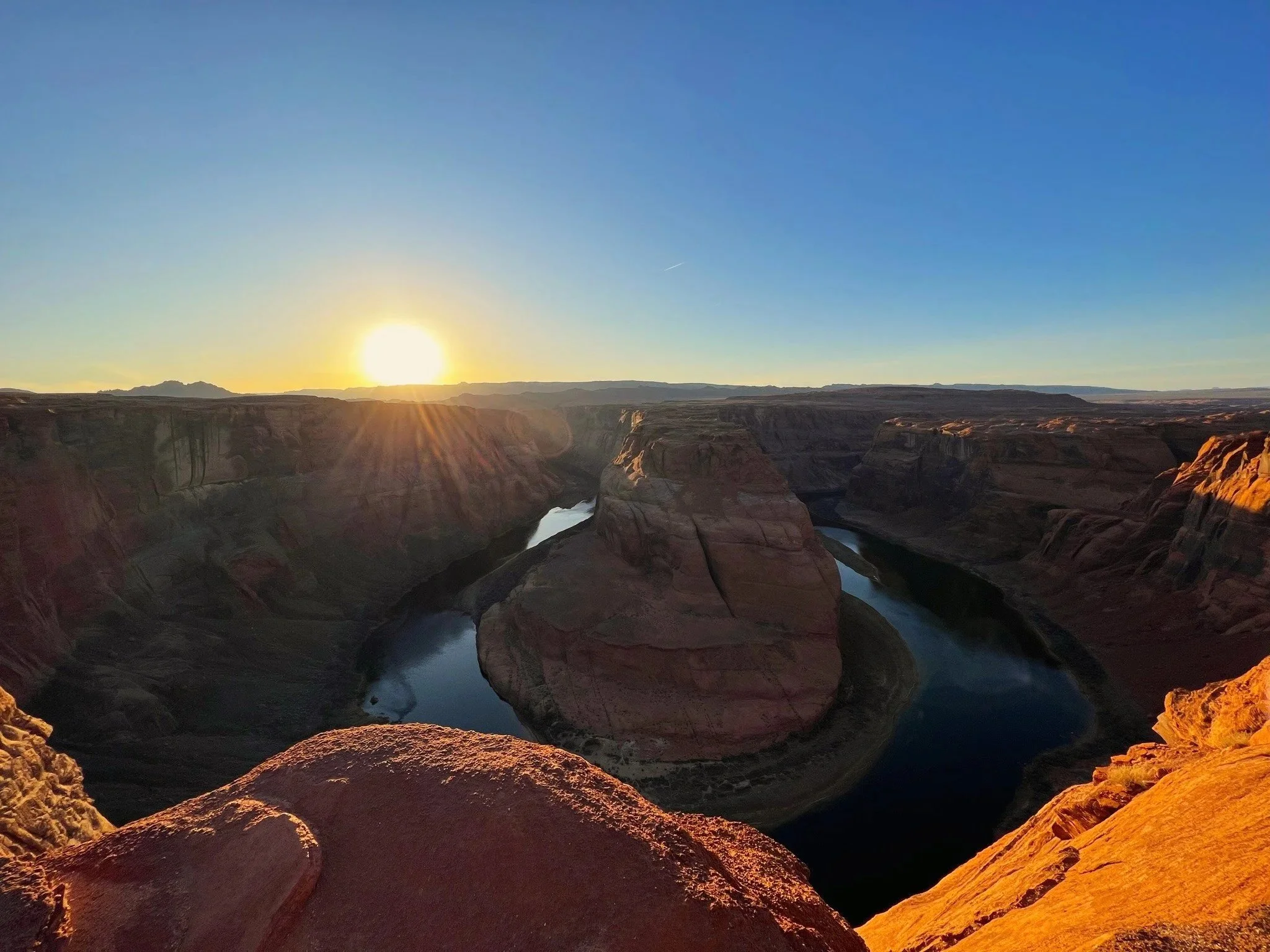
Afternoon: Horseshoe Bend (2-4 pm)
The iconic view you've seen a million times: the Colorado River making a perfect 270° curve through red rock cliffs, 1,000 feet below.
The hike: 1.5 miles round trip, easy but hot (zero shade). Paved and sandy trail.
Best time: Late afternoon for better light, or sunrise to avoid crowds. Midday is harsh light and packed.
What you need:
Water (bring extra, people get heat exhaustion here)
Wide-brim hat
The mental preparation to see 500 other people at a "natural wonder"
Important safety note: There are no railings at the edge. It's a sheer 1,000-foot drop. Stay back from the edge and don't do anything stupid for a photo. People have died here taking selfies.
Why it's still worth it despite the crowds: Because it's objectively spectacular. The scale, the color, the perfect curve, it's one of nature's finest moments.
Entry: $10/vehicle
Evening: Rest up for tomorrow's early Antelope Canyon tour. Page has limited dinner options, but here are the best:
Dinner:
Big John's Texas BBQ (locals' favorite, $$)
Bonkers (sports bar, burgers, $)
Fiesta Mexicana (solid Mexican, $$)
WHERE TO STAY:
Book Page hotels on Booking.com
Budget: Super 8 ($80-120)
Mid-range: Hampton Inn ($120-180)
Splurge: Hyatt Place Page / Lake Powell ($150-220)
Day 8: Antelope Canyon + Lake Powell
Overnight: Page
Today's the day you've been waiting for: Antelope Canyon.
Morning: Antelope Canyon Tour (Time Varies by Booking)
First, understand: You CANNOT visit Antelope Canyon without a Navajo guide. This slot canyon is on Navajo Nation land, and tours are required both to protect the site and because flash floods make it dangerous.
Upper vs Lower Antelope Canyon:
Upper Antelope (Tsé bighánílíní - "the place where water runs through rocks"):
Wider, easier to walk through
Ground-level entry (no stairs)
Famous light beams (only mid-morning/midday March-October)
MORE EXPENSIVE ($60-90/person)
More crowded
Shorter tour (45-60 min)
Lower Antelope (Hasdeztwazi - "spiral rock arches"):
Narrower, more intimate
Requires climbing metal stairs to enter and exit
No light beams, but stunning curved walls
CHEAPER ($30-60/person)
Still crowded but slightly less
Longer tour (60-90 min)
My recommendation: Lower Antelope. You get more time, it's more intimate, and the swirling walls are equally photogenic. Save the extra $30 for a better dinner.
Light Beams: If light beams are your priority, book Upper Antelope for a midday tour (11 am-1 pm) in March-October. Outside these times, no beams.
Photography Tips:
Your phone camera is fine; modern phones handle the lighting well
If using a real camera, shoot in manual mode (guides will help you with settings)
Don't use flash
Be patient; guides will help you get the shot
Remember to look up from your phone and just EXPERIENCE it
Important: Tours book up weeks (sometimes months) in advance. Book as early as possible.
Afternoon: Lake Powell Activities (1-5 pm)
After Antelope Canyon, you have options:
Option 1: Glen Canyon Dam Tour (1.5 hours, $15): An engineering marvel that created Lake Powell. Interesting if you like infrastructure and history. Controversial among environmentalists (the dam flooded Glen Canyon, a landscape John Wesley Powell called more beautiful than the Grand Canyon).
Option 2: Rent a Kayak/Paddleboard on Lake Powell: Multiple marinas rent equipment.
Option 3: Scenic Drive to Wahweap Overlook: Free viewpoint overlooking Lake Powell. 10 minutes from town, spectacular sunset spot.
Option 4: Rest: You've been going hard for a week. Rest by the hotel pool with a book. Not every moment needs to be optimized.
Evening: Watch sunset at Lake Powell. The reservoir reflects red rocks in the water—it's gorgeous (and quieter than Horseshoe Bend).
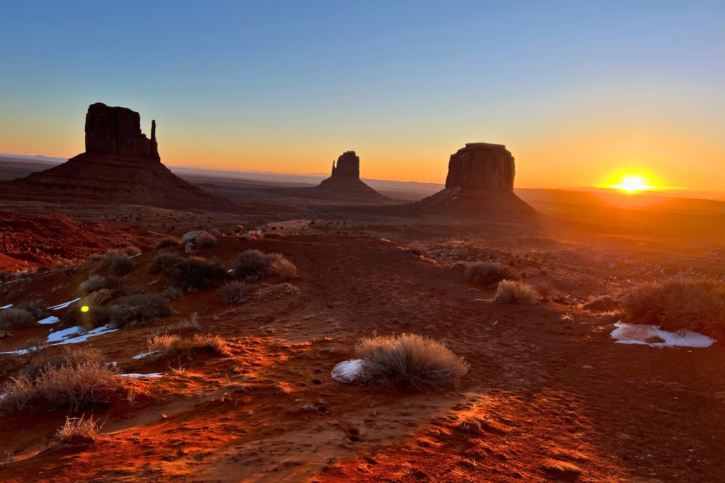
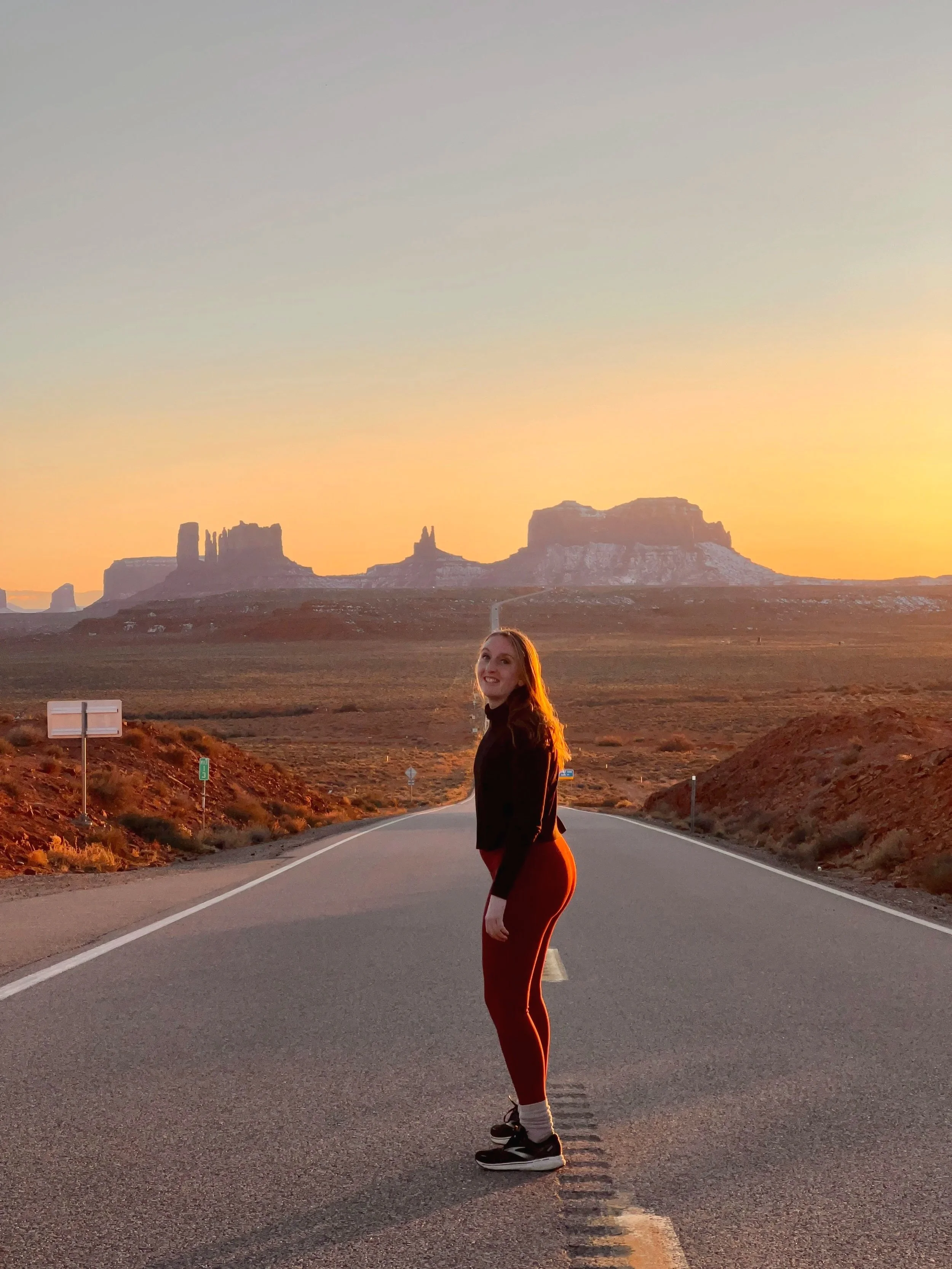
Day 9: Monument Valley (Optional Detour) OR Return via Cameron
Drive Time: 2 hours Page to Monument Valley (one-way)
Overnight: Page OR head toward Flagstaff
This day offers two very different options depending on your interests and energy levels.
Option A: Monument Valley Journey (Full Day)
Monument Valley is 2 hours southeast of Page, on the Arizona-Utah border. The drive alone is stunning—flat desert suddenly interrupted by massive sandstone buttes rising hundreds of feet.
OR stay the night at the View Hotel for panoramic window views and good food
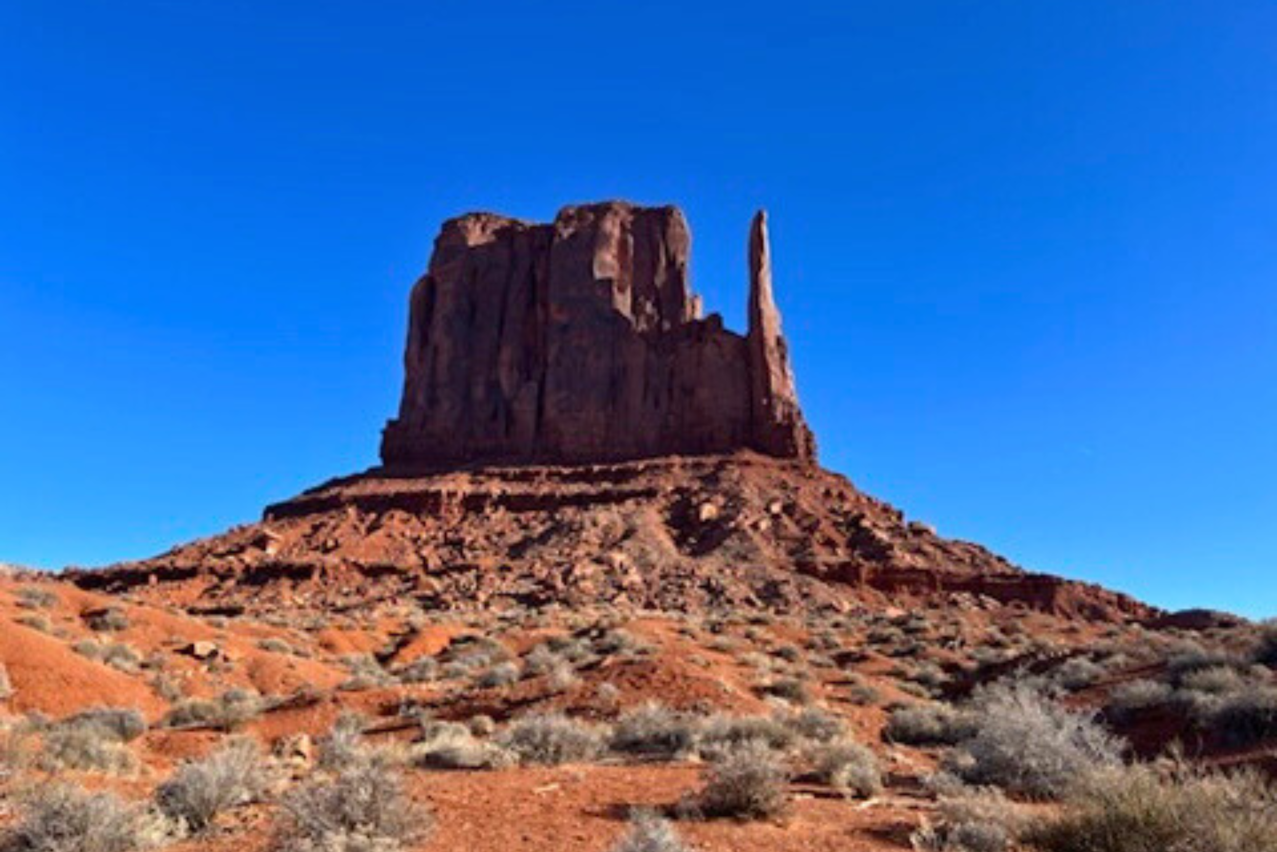
Why Monument Valley matters:
This is Navajo Nation sacred land. Every formation has meaning and stories passed down through generations. The iconic landscape you've seen in Western films and car commercials is actually called Tsé Biiʼ Ndzisgaii ("valley of the rocks") and holds deep spiritual significance for the Diné (Navajo) people.
17-Mile Scenic Loop Drive:
Unpaved road through the valley ($8/person entry)
Requires a high-clearance vehicle (SUV minimum)
Takes 2-3 hours
Self-drive allows stops at viewpoints
Expect washboards and bumps
Why hire a Navajo guide (recommended):
Access to restricted areas (most of Monument Valley is off-limits without a guide)
Cultural context and stories about the formations
Directly supports Navajo families
Learn about sheep herding, traditional hogan, and modern life on the Nation
Usually 2-4 hour tours, $60-150/person
Sunrise or sunset (light is magical, temps are comfortable)
Private tours offer more flexibility than group tours
Some guides take you to ancient petroglyphs and less-visited areas
"Forrest Gump Point": Mile marker 13 on US-163, where Forrest stopped running. Photo op, but it's actually in Utah just past the border.
Option B: Relaxed Return to Flagstaff (Half Day)
If Monument Valley feels like too much driving or you're exhausted, take the scenic route back to Flagstaff via Cameron and the Painted Desert.
Cameron Trading Post (Longer Visit):
Browse the gallery (museum-quality Native American art)
Walk the suspension bridge over the Little Colorado River
Lunch at the restaurant
Actually shop for authentic jewelry, rugs, and pottery
Painted Desert Overlooks:
Highway 89 passes through sections of the Painted Desert
Pull over at scenic overlooks
These badlands change color throughout the day
Arrive in Flagstaff by afternoon:
Relax, do laundry, recover
Explore downtown Flagstaff, you haven't seen it yet
Early dinner and early sleep
Evening: Whether in Page or Flagstaff, you're wrapping up the core road trip. Tomorrow's a transition day.
Day 10: Flagstaff to Phoenix + Final Stops
Drive Time: 2.5 hours, Flagstaff to Phoenix
Overnight: Phoenix (or fly out)
Your final day brings you full circle, or launches you toward your next adventure.
Morning: Flagstaff Farewells (8-11 am)
If you haven't explored Flagstaff properly, spend your morning here:
Downtown Flagstaff Walk:
Heritage Square (historic downtown)
Beaver Street Brewery (lunch before you leave)
Local coffee shops and bookstores
Lowell Observatory (Optional, 9 am-10:30 am): Where Pluto was discovered in 1930. If you're an astronomy nerd, this is a great last stop. If not, skip it and head south.
Late Morning: Drive South + Optional Stop at Montezuma Well (11 am-1 pm)
Montezuma Well (different from Montezuma Castle):
Large limestone sinkhole filled with water
Ancient irrigation systems are still visible
Ancestral Puebloan and Hohokam cultures used it for farming
Free entry, 30-minute stop
Why it's cool: This natural well provides 1.5 million gallons of water daily and has for thousands of years. The irrigation ditches carved into the rocks are 1,000+ years old and still flow.
Afternoon: Arrive Phoenix (2-4 pm)
Depending on your flight time:
Time to kill?
Desert Botanical Garden ($30/person) - 50,000 desert plants, beautiful
Heard Museum ($25/person) - Exceptional Native American art and history museum
Old Town Scottsdale - Shopping, galleries, lunch
Tight schedule?
Return the rental car
Airport
Flight home
Evening: Fly home with a memory card full of photos, red desert dust still in your shoes, and a profound new relationship with the American Southwest.
Hidden Gems & Off-the-Beaten-Path Stops
These didn't fit the main itinerary but are worth knowing about:
Lava River Cave (Flagstaff Area)
A mile-long lava tube you can walk through with just a flashlight. It's like exploring an underground tunnel carved by flowing lava. Free, but requires a permit (get at the forest service visitor center).
Bring: Multiple flashlights (it's DARK), warm jacket (it's 42°F inside year-round), sturdy shoes (the floor is uneven lava rock).
Sycamore Canyon Wilderness
Arizona's second-largest canyon (after Grand Canyon), near Sedona. Far fewer visitors, rugged hiking, true wilderness. For experienced hikers only.
Meteor Crater
A 50,000-year-old impact crater you can drive to. It's privately owned ($30/person), touristy, but impressive if you're into space and geology. Located off I-40 between Flagstaff and Winslow.
Worth it? Debatable. Some love it, others feel it's overpriced for looking at a hole. If you're a space nerd, go. Otherwise, save your money.
Prescott
A charming mountain town with the "world's oldest rodeo," Victorian-era Whiskey Row, and mild weather. Great for a day trip from Sedona or Flagstaff. More locals than tourists.
Oak Creek Canyon in Fall
If you're visiting in late September/October, drive Highway 89A through Oak Creek Canyon specifically to see fall colors. Oaks, maples, and cottonwoods turn gold and red against the red rocks—stunning.
Cultural & Intentional Travel Tips
Respecting Indigenous Lands
Virtually every place you visit on this trip is on ancestral or current Indigenous land. Here's what that means:
Whose Land?
Sedona/Verde Valley: Yavapai-Apache Nation, Western Apache
Flagstaff/Grand Canyon: Havasupai, Hualapai, Kaibab Paiute, Navajo, Hopi, Zuni (and more—11 tribes have connections to Grand Canyon)
Page/Monument Valley/Antelope Canyon: Navajo Nation (Diné)
How to Travel Respectfully:
Learn Before You Go: Understand whose land you're on and what it means to them. The Grand Canyon isn't just scenery—it's the origin place for the Hopi people, a sacred site for the Havasupai, and holds significance for many other tribes.
Support Native-Owned Businesses:
Hire Navajo guides for Antelope Canyon and Monument Valley
Buy from Native artists (not from white-owned shops selling "Native-style" items)
Visit tribal museums (Heard Museum in Phoenix, Museum of Northern Arizona)
Follow Navajo Nation Rules:
No alcohol on the Nation (it's illegal)
Ask before photographing people
Respect "No Trespassing" signs
Never remove artifacts or touch petroglyphs
Leave No Trace in Fragile Desert
Critical reminders:
Pack out ALL trash (even organic waste like apple cores—they attract animals and disrupt ecosystems)
Stay on trails - Desert biological soil crusts (black, crusty ground) take 100+ years to regenerate if stepped on
Don't build cairns - Random rock stacks confuse hikers and disrupt micro-habitats
Poop properly - 200 feet from water, bury 6-8 inches deep, pack out TP (or use natural materials)
Don't move rocks or disturb wildlife
Leave what you find - Artifacts are protected by federal law; take photos, not items
Supporting Local Communities
Where your money matters most:
Eat at locally-owned restaurants over chains
Stay at independent hotels/inns when possible
Shop at local outfitters for gear and supplies
Book local guides (not national companies that outsource)
Tip well - Tourism economies are seasonal, and locals depend on it
Sustainable Travel Practices
Carpool/share rides when doing tours (reduces vehicle traffic)
Refill water bottles at visitor centers instead of buying disposable ones
Use reef-safe sunscreen (regular sunscreen harms aquatic ecosystems)
Stay on designated roads (off-roading destroys cryptobiotic soil)
Practical Road Trip Tips
Gas Station Strategy
Reality: Gas stations can be 50-80 miles apart. Never let your tank drop below half on these stretches:
Page to Monument Valley
Flagstaff to Grand Canyon
Cameron to Page
Most expensive gas: Page, Grand Canyon area, small towns
Best prices: Flagstaff, Phoenix/Scottsdale, Sedona
Water & Hydration
Minimum: 1 gallon per person per day, more if hiking.
Dehydration signs:
Dark urine
Headache
Dizziness
Fatigue
Hydration tips:
Drink BEFORE you're thirsty
Add electrolytes for long hikes (Liquid IV, Nuun, Pedialyte)
Avoid alcohol the night before big hiking days
Fill up at visitor centers (free filtered water)
Rapid Hydration (essential for desert hiking)
LifeStraw Go Series Water Filter (for backcountry water sources)
Avoiding Crowds
Golden rules:
Start early - Be on trails by 7am for popular hikes
Weekdays > weekends - Dramatically fewer people Tuesday-Thursday
Shoulder seasons - Early May and late September are ideal
Sunset > midday - Most tourists leave by 5pm
Specific strategies:
Grand Canyon: Hermit Trail instead of Bright Angel
Sedona: West Fork Trail instead of Devil's Bridge
Antelope Canyon: Lower instead of Upper (slightly less crowded)
FAQ for Visiting Northern Arizona
-
Seven days is tight but possible if you focus on the "Big Three": Grand Canyon (2 days), Sedona (2 days), and Page/Antelope Canyon (1-2 days). You'll miss hidden gems like Wupatki, Jerome, and Monument Valley. Ten days is recommended for a complete experience without feeling rushed.
-
The optimal route is: Phoenix → Sedona (3 days) → Flagstaff (2 days) → Grand Canyon (2 days) → Page (2 days) → return to Phoenix or fly out of Las Vegas. This minimizes backtracking and follows a logical geographic progression. Total driving: approximately 800-1,000 miles.
-
No. Antelope Canyon is on Navajo Nation land and requires a guided tour for safety (flash flood risk) and to protect the site. Tours cost $30-90 depending on Upper vs Lower canyon and must be booked through authorized tour companies. Solo entry is not permitted under any circumstances.
-
Light beams in Upper Antelope Canyon are only visible during specific conditions: midday (11am-1pm) from mid-March through early October when the sun is high enough to shine directly into the canyon. Lower Antelope Canyon doesn't have light beams but has equally beautiful swirling walls year-round.
-
Yes, Northern Arizona is very safe for solo travelers. The main risks are environmental (heat exhaustion, dehydration, getting lost) rather than crime. Standard precautions: tell someone your hiking plans, carry extra water, check weather before slot canyons, don't hike alone on remote trails, and trust your instincts.
-
Spring (March-May): Days 50-75°F, nights 30-45°F. March can have snow at high elevations (Grand Canyon, Flagstaff). April-May is ideal with mild temps and wildflowers. Pack layers.
Fall (September-October): Days 60-75°F, nights 35-50°F. Early September can still be warm. Late September-October brings fall colors and perfect hiking weather. Grand Canyon North Rim closes mid-October.
-
Most hikes don't require permits. Exceptions: Grand Canyon overnight backpacking (permit required, apply 4 months ahead), The Wave at Coyote Buttes (lottery system, very competitive), some Navajo Nation backcountry areas. Day hikes at Grand Canyon South Rim, Sedona, and most trails don't need permits—just parking passes.
The Scenic Route Traveler inspires intentional travel through storytelling, hidden gems, and culturally rich experiences around the world.
-
I’m Erin, the voice behind Scenic Route Traveler, sharing intentional travel stories and guides from around the globe.
-
We deliver travel guides and storytelling through YouTube, social media, photography, and digital products designed for fellow travelers.
-
If you’re new here: this is a space for travelers who care more about how a place feels than how it looks on a checklist. You’ll find guides, stories, and resources designed to help you slow down and travel with intention.